

|
|
|
|
|
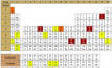
Maps have been produced for numerous geographic regions, illustrating the macroscopic variations in atmospheric corrosivity and pollution levels.
Marine atmospheres are usually highly corrosive, and the corrosivity tends to be significantly dependent on wind direction, wind speed and distance from the coast. However, an equivalently corrosive environment is created by the use of deicing salts on the roads of many cold regions of the planet. Traditional techniques for monitoring the pollutants sulfur dioxide and atmospheric chloride that influence corrosivity need to be conducted for extended periods to be site representative, and are consequently expensive. Furthermore, measurements made at limited numbers of sites do not adequately represent the variations in pollutant levels across a region or city.
However the exposure of standard metal specimens at a grid of sites and the generation of computer contoured corrosion maps has been shown to be a sensitive and cost-effective means of differentiating geographical variations in corrosivity, which is a measure of the aggressiveness of the environment. Such specimens can also be regarded as receptors for airborne pollutants and provide a means for readily characterizing their geographical variations. The techniques for doing this were described in a paper "Contour Mapping the Sulfur and Chlorine Contents of Steel Corrosion Products - A New Approach for Characterising the Atmospheric Environment" by George King, Mark Spicer and Pon Kao from CSIRO Division of Building, Construction & Engineering Australia presented at the 13th ICC in Melbourne (1996)
![]()