Amazon Rainforest Tipping Point
Amazon rainforest damage surges 67% in 2008
The area of rainforest in the process of being deforested (razed but
not yet cleared) surged in the Brazilian Amazon during 2008,
according to new figures released by Brazil's National Institute for Space
Research (INPE). The announcement comes shortly after the Brazilian government
reported a 4% increasein forest clearing for the year. (reference)
Deforestation presently accounts for more than half of Brazil's
greenhouse gas emissions. As such, the government sees forest
conservation as a means to reduce emissions, but believes industrialized
countries should help pay for it. In August President Luiz Inacio Lula da Silva
unveiled a $21 billion donation-based fund to finance conservation and
sustainable development projects in the region. Norway has already committed a
billion dollars to the initiative.
A Vicious Circle
The hot, wet Amazon normally evaporates vast amounts of water, which rise
high into the air as if in an invisible chimney. This draws in the wet
north-East trade winds, which have picked up moisture from the Atlantic. This in
turn controls the temperature of the ocean; as the trade winds pick up the
moisture, the warm water that is left gets saltier and sinks. Deforestation
disrupts the cycle by weakening the Amazonian evaporation which drives the whole
process. One result is that the hot water in the Atlantic stays on the surface
and fuels the hurricanes. Another is that less moisture arrives on the trade
winds, intensifying drought in the forest. (reference)
Vast plumes of smoke from forest fires and agricultural burning are common in
the tropics. Satellite evidence shows that these plumes reduce rainfall
production and create huge rain-shadows over downwind areas. Rainforests return
water to the atmosphere by transpiration from leaves. This is perhaps the most
important regional ecosystem service, providing valuable moisture to downwind
regions. Large-scale conversion of rainforest to pasture or cropland has the
potential to undermine this service. (reference)
So far about a fifth of the Amazonian rainforesthas been razed completely.
Another 22 per cent has been harmed by logging, allowing the sun to penetrate to
the forest floor drying it out. And if you add these two figures, the
total is growing perilously close to 50 per cent, a threshold
that current models predict
as the tipping pointthat marks the death of the Amazon. These models did not
predict this to occur before2050. However, the latest estimates
indicate that the tipping point is indeed imminent.
The Amazon rainforest is the largest store of magnificent biodiversity on the
planet, yet huge acreage continues to be destroyed by humans every year, both
illegally and legally, due to agriculture, mining, cattle ranching,
burning, and logging for timber. The Amazon Riverand
its tributaries, teeming with life, and the beautiful creatures who live in the
coastal and forest areas around these waters, are also threatened by proposed
hydroelectric dams.
|
Incredibly, tropical rainforests are so fantastically rich with life,
that although only 6% of the Earth’s surfaceis covered
by rainforest, this 6% contains 50% of the world’s species.
And, the Amazon rainforest which spans Brazil, Ecuador, Colombia,
Suriname, Peru, French Guiana, Bolivia, Guyana and Venezuela remains the
single largest area of rainforest in the world. In
fact, the Amazon contains over half of the world’s total
rainforest.(reference)
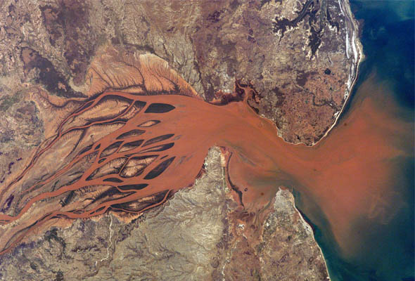
The picture on the right provides an aerial view of sediment run-off
caused by massive deforestation. This entire area has been stripped bare
of forest, so there are no longer any plants, bushes or tree roots to
hold soil...which runs off into rivers and streams, killing marine life,
even after the animals on land have been killed due to deforestation.
|
 |
Until 2005, the only method used to monitor the progress of deforestation was
the Amazon deforestation estimate project (PRODES, the
Portuguese acronym), an annual analysis of around 200 high-resolution images
taken of the Amazon region by the NASA Landsat satellite,
supplemented by other satellite data when there are problems of cloud cover. By
comparing vegetation cover within each image with those of the previous year, it
is possible to get a pretty accurate estimate of the deforestation that has
taken place in those 12 months. (reference)
The problem with this system was that by the time the complex analysis of
each year's deforestation was complete, the damage has long since been done. It
could therefore only be used as a historical record and of little use in aiding
the authorities to chase after illegal deforesters. So in 2005a new system was introduced as part of the Lula government's Amazon
Deforestation Action Plan. The detection of deforestation in real time
(DETER) system is designed to complement rather than replace
PRODES. As the name suggests, the idea is to get data back
quickly, using different satellites that generate much more frequent images,
albeit at a lower resolution. Analysis from the DETER system is available
every two weeks or so, and given the vastness of the Amazon
region, the theory is that this should give the authorities valuable information
about new areas of deforestation and guidance on where they should be
concentrating their enforcement efforts.
The dynamics of deforestation in the Amazon are complex. he process tends to
follow a distinct pattern: first a rainforest area is logged for its valuable
lumber, then burned for cattle grazing, and as the land becomes exhausted, it is
plowed up for crops such as soybeans. What is undoubtedly true is that the
number of cattle in the Amazon has increased dramatically in recent years. The
number of cattle in the Amazon region had reached 74 million in 2007,
outnumbering people by more than three to one. Cattle numbers in the Amazon had
grown 46 percentin just three years and the region had
accounted for virtually the entire increase in the size of the Brazilian cattle
herd between 2003 and 2006.
You want to share some ideas, or data with the visitors of the
Corrosion Doctors Web site please send a note
to our
Climate tipping points: Amazon Rainforest, Arctic Sea-Ice,
Atlantic Thermohaline Circulation,
Greenland Ice Sheet,
Sahara/Sahel